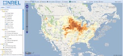
 Want to know where are the biorefineries in the U.S. are located? There’s an app for that. The National Renewable Energy Lab (NREL) has released a new bioenergy mapping portal, BioEnergy Atlas, that identifies biomass feedstocks, then overlays that information with the ethanol and biodiesel facilities both on and off-line. You can also see map information for transportation infrastructure, power plants, fueling stations, and more. The tools are coined BioPower Atlas and BioFuels Atlas.
The portal was created with funding help from the Environmental Protection Agency’s Blue Skyways Collaborative and the Department of Energy’s Biomass Program. Not only is the map able to identify current biorefinery locations, but can also show where copious amounts of biomass are available for harvest without plants located in the region. Perfect for those looking for areas of untapped energy potential.
According to NREL, BioEnergy Atlas is targeted to a multitude of users including government and state agencies, universities, the petroleum and pipeline industries, research institutions, vehicle manufacturers, investment firms, GIS companies, private citizens, and media.

